fbpx
Breaking News
Securely Travel - Hurricane Ian - 29 September 2022

Ian grows to a Category 4 Hurricane - Resources

Spread the knowledge with a share:

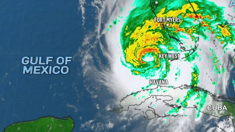
According to the National Hurricane Center, Hurricane Ian has sustained winds of 140 mph and as of 0500 hours on 28 September, the center of Hurricane Ian is located about 75 miles/ 125kmw WSW of Naples, Florida.

Note: At the bottom of this page are updates issued by the NHC for Hurricane Ian, to include localized information for various Florida metro areas.

FLORIDA PUBLIC SAFETY

The following compilation of information is drawn from FloridaDisaster.org a part of the Florida division of emergency management,

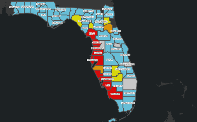
Evacuation orders: The map below will take you to the dynamic map which provides information for each of the Florida counties and their current status with respect to evacuation orders. Those areas in red are currently under MANDATORY evacuation orders.

https://www.floridadisaster.org/evacuation-orders/

Emergency Accommodations: Expedia is working with the state to assist in the location of accommodations.

LINK: SEARCH FLORIDA ACCOMODATIONS

Shelter Status and Openings: The state emergency management system maintains a dynamic listing of Florida shelters which is updated every few minutes.

If you are in need of shelter: LINK: FLORIDA SHELTERS

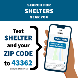
FEMA also has available information by texting the word “SHELTER” and your “ZIPCODE”

State Assistance Information Line: 1-800-342-3557

The Florida State Assistance Information Line (SAIL) has been activated to provide an additional resource for Floridians to receive up-to-date information regarding Hurricane Ian. Residents and visitors can call this toll-free hotline at 1-800-342-3557.

STORM SURGE

The NHC continues to emphasize the deadly nature of storm surge:

Securely Travel - National Hurricane Center Logos
STORM SURGE:  The combination of storm surge and the tide will cause normally dry areas near the coast to be flooded by rising waters moving inland from the shoreline.  The water could reach the following heights above ground somewhere in the indicated areas if the peak surge occurs at the time of high tide...
* Middle of Longboat Key to Bonita Beach, including Charlotte 
Harbor...8-12 ft
* Bonita Beach to Chokoloskee...6-10 ft
* Anclote River to Middle of Longboat Key, including 
Tampa Bay...4-6 ft
* Chokoloskee to East Cape Sable...4-7 ft
* Suwannee River to Anclote River...3-5 ft
* Lower Keys from Key West to Big Pine Key, including the 
Dry Tortugas...3-5 ft
* Flagler/Volusia County Line to Savannah River including St. Johns 
River...3-5 ft
* St. Johns River south of Julington...2-4 ft
* Savannah River to South Santee River...2-4 ft
* East Cape Sable to Card Sound Bridge...2-4 ft
* Florida Keys east of Big Pine Key...2-4 ft
* Patrick Air Force Base to Flagler/Volusia County Line...1-3 ft
* Indian Pass to Suwanee River...1-3 ft
The deepest water will occur along the immediate coast near and to
the right of the center, where the surge will be accompanied by
large waves.  Surge-related flooding depends on the relative timing
of the surge and the tidal cycle, and can vary greatly over short
distances. 

NHC Updates - Hurricane Ian (updated every 30 mins)

Securely Travel - National Hurricane Center Logos
Published on 2022-09-28
Issued at 700 AM EDT Wed Sep 28 2022… Read more
Securely Travel - National Hurricane Center Logos
Published on 2022-09-28
…RAPIDLY INTENSIFYING IAN FORECAST TO CAUSE CATASTROPHIC STORM SURGE, WINDS,… Read more
Securely Travel - National Hurricane Center Logos
Published on 2022-09-28
Issued at 1100 UTC WED SEP 28 2022… Read more
Securely Travel - National Hurricane Center Logos
Published on 2022-09-28
Issued at 1100 UTC WED SEP 28 2022… Read more
Securely Travel - National Hurricane Center Logos
Published on 2022-09-28
Issued at 600 AM EDT Wed Sep 28 2022… Read more
Securely Travel - National Hurricane Center Logos
Published on 2022-09-28
…6 AM EDT HURRICANE IAN POSITION UPDATE… …CONDITIONS RAPIDLY DETERIORATING… Read more
Securely Travel - National Hurricane Center Logos
Published on 2022-09-28
Issued at 542 AM EDT Wed Sep 28 2022… Read more
Securely Travel - National Hurricane Center Logos
Published on 2022-09-28
Issued at 538 AM EDT Wed Sep 28 2022… Read more
Securely Travel - National Hurricane Center Logos
Published on 2022-09-28
Issued at 532 AM EDT Wed Sep 28 2022… Read more
Securely Travel - National Hurricane Center Logos
Published on 2022-09-28
Issued at 530 AM EDT Wed Sep 28 2022… Read more
Securely Travel - National Hurricane Center Logos
Published on 2022-09-28
Issued at 522 AM EDT Wed Sep 28 2022… Read more
Securely Travel - National Hurricane Center Logos
Published on 2022-09-28
Issued at 521 AM EDT Wed Sep 28 2022 /421… Read more
Securely Travel - National Hurricane Center Logos
Published on 2022-09-28
Issued at 518 AM EDT Wed Sep 28 2022… Read more
Securely Travel - National Hurricane Center Logos
Published on 2022-09-28
Issued at 0… Read more
Securely Travel - National Hurricane Center Logos
Published on 2022-09-28
Issued at 500 AM EDT Wed Sep 28 2022… Read more
Securely Travel - National Hurricane Center Logos
Published on 2022-09-28
Storm Surge Watch/Warning Map last updated Wed, 28 Sep 2022… Read more
Securely Travel - National Hurricane Center Logos
Published on 2022-09-28
GIS Data last updated Wed, 28 Sep 2022 08:58:51 GMT… Read more
Securely Travel - National Hurricane Center Logos
Published on 2022-09-28
GIS Data last updated Wed, 28 Sep 2022 08:58:51 GMT… Read more
Securely Travel - National Hurricane Center Logos
Published on 2022-09-28
GIS Data last updated Wed, 28 Sep 2022 08:58:51 GMT… Read more
Securely Travel - National Hurricane Center Logos
Published on 2022-09-28
GIS Data last updated Wed, 28 Sep 2022 08:58:21 GMT… Read more
Securely Travel - National Hurricane Center Logos
Published on 2022-09-28
5-Day Uncertainty Track last updated Wed, 28 Sep 2022 08:57:44… Read more
Securely Travel - National Hurricane Center Logos
Published on 2022-09-28
Issued at 0900 UTC WED SEP 28 2022… Read more
Securely Travel - National Hurricane Center Logos
Published on 2022-09-28
Issued at 0900 UTC WED SEP 28 2022… Read more
Securely Travel - National Hurricane Center Logos
Published on 2022-09-28
Issued at Wed, 28 Sep 2022 08:55:34 GMT. This is… Read more
Spread the knowledge with a share:

About Christopher Burgess

Christopher Burgess is a writer, speaker and commentator on global security issues. He has appeared on CNN, BBC, I24, China News, Bloomberg, CBS, NBC, and ABC providing commentary and analysis. He is a former Senior Security Advisor to Cisco and served 30+ years within the CIA which awarded him the Distinguished Career Intelligence Medal upon his retirement. He has lived and traveled abroad for more than 55 years. Christopher co-authored the book, “Secrets Stolen, Fortunes Lost, Preventing Intellectual Property Theft and Economic Espionage in the 21st Century.” He is the founder of Securely Travel.

Check Also

AA337 - Cabo to LAX - Passenger Violence in the Sky

An Orange County, California man is facing Federal charges, following his assault on a crew …

Securely Travel - Travel Alert for 20 September 2022

Securely Travel Alert - 20 September 2022

SUMMARY: Hurricane Fiona aftermath in Puerto Rico is substantial. According to LUMA, power much of …

%d bloggers like this:

Please click to accept our use of Cookies. more information

The cookie settings on this website are set to "allow cookies" to give you the best browsing experience possible. If you continue to use this website without changing your cookie settings or you click "Accept" below then you are consenting to this. This cookie acceptance is for a period of 90 days.

Close